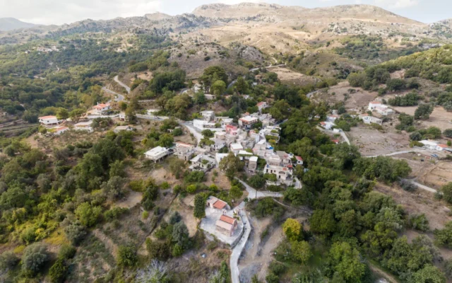
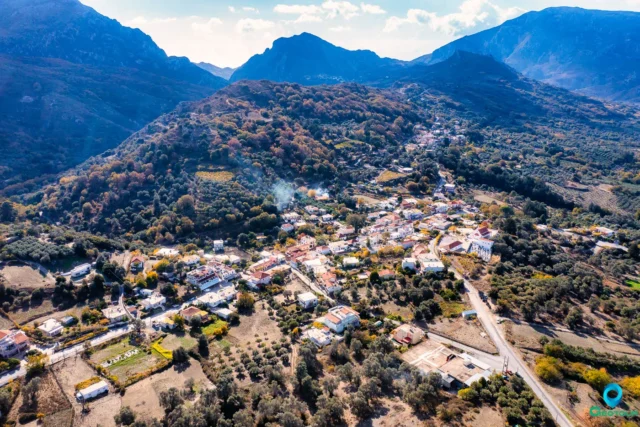
Kissos is a mountainous village and seat of the homonymous community in the Municipality of Agios Vasileios, in the Rethymno Regional Unit of Crete. It is built on the southwestern foothills of Mount Kedros at an altitude of 630 meters. Kissos is 33 kilometers from Rethymno, the capital of the prefecture, and 6 kilometers from Spili, the seat of the municipality of Agios Vasileios. The plateau of Yous Campos is located above the village, which in earlier years was an important source of food for Kissos and the other villages of the wider area.
History
Early years and progress over time
It is believed that the settlement was created before the 10th century and took its name from the plant of the same name that thrives in the area. The earliest reference to Kissos dates back to the Venetian occupation. According to research by Stergios Spanakis, Kissos is recorded in 1577 in the catalog “Descrizione dell’ Isola di Creta” by Francesco Barozzi as Chisso. In 1583 it is mentioned in the census of the Castellan with a population of 222 inhabitants.
In 1630, Vasilakata records 178 forced labors owed, while according to the Ottoman records of 1659, the settlement had 33 taxable households. A few years later (c. 1670 to 1673), according to Ottoman statistics, Kissos belonged to the Agios Vasileios nakhiye and had 72 owners, of whom 69 were Christians and the remaining three were Muslims. In the Egyptian census of 1832, which is reproduced by the English traveler Robert Pashley, who visited Crete two years later, Kissos is recorded as a mixed settlement with 15 Christian families and an equal number of Muslim ones.
In July 1867, Ottoman soldiers who were conducting clearing operations against Greek revolutionaries operating in the wider area spent the night in Kissos. In 1881 Kissos belonged to the Ottoman municipality of Agios Pnevmatos and had 208 inhabitants (181 Greeks and 27 Turkish Cretans), while according to the census conducted in 1900 by the authorities of the Cretan State, its population amounted to 213 inhabitants (104 men and 109 women, all Greeks).
Within the framework of the Greek state
Three residents of the settlement were killed as soldiers in the Asia Minor campaign, while during the Occupation, the local population actively participated in the National Resistance through the ranks of ELAS Crete and EOK. At the same time, two people from Kissos were killed as ELAS and EDES guerrillas (the second in mainland Greece), while on May 25, 1944, German forces captured about 50 residents, killing one who tried to escape.
The electrification of Kissos took place in 1968, while the problem of water supply was definitively solved in the mid-1980s, at the same time that the telephone connection was made.
Administratively, after the Union of Crete with Greece, Kissos was placed under the province of Agios Vasileios where it remained until 1997. In 1928 it was included in the community of Ardaktos and in 1935 it became the seat of a community which later included the newly built Kissos Campos. With the implementation of the “Kapodistrias” plan, it was placed under the municipality of Lampis, while since 2011 it has belonged to the Kallikratis municipality of Agios Vasileios.
Points of interest
Churches
The three churches within Kissos, together with the historic monastery of Agios Pnevmatos and the renovated chapel of Agia Paraskevi, which are located at a short distance, form a network of Byzantine and post-Byzantine monuments.
The Church of the Transfiguration of the Savior
The parish church, which is dedicated to the Transfiguration of the Savior, is located on the southern side of the village. It is a two-aisled basilica with a two-aisled plan, without a dome, with equally high, tiled and gable roofs, and its construction dates back to the 14th century. The church is mentioned in the work “Monumenti Veneti nell’ isola di Creta” by the Italian historian Giuseppe Gerola, who carried out field research in Crete from 1900 to 1902. Its founder is mentioned as Dimitrios Vergil, whose figure is preserved in a fresco at the western end of the interior of the church. The original construction was altered by later additions such as the small window next to the psalter-analogue and the second aisle. It was restored externally by the Byzantine Antiquities Ephorate in the mid-1970s, with the result that the two aisles now appear as a single structure. Further maintenance and beautification works were carried out later.
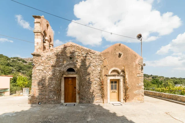
The Church of the Virgin Mary
Built on the eastern side of Kissos, it is the village’s cemetery church and is dedicated to the Nativity of the Virgin Mary. Its construction dates back to the beginning of the 14th century. It is a simple and single-room building that follows the classic architectural type that prevailed in the Cretan countryside during the period of its construction. At the beginning of the 20th century, works were carried out to extend it to the west, with the addition of an arch, the opening of a rectangular entrance door on the south side and the window next to the psalter, as well as the addition of the embossed bell tower. The church has frescoes from the 14th century and an icon of Christ Pantocrator which dates back to 1840.
The Church of Panagia is traditionally associated with the procession of the Epitaphios and the Resurrection services, while on Holy Saturday the custom of “burning Judas” took place.
The Church of Saint John
It is located at the northwestern end of the village and is dedicated to Saint John the Theologian. It is single-aisled with a gable, tiled roof and is partly built on a rock, while at an unknown period widening works were carried out towards the west side. Internally it is inscribed and has two layers of frescoes, with the oldest dating from the end of the 13th century. The outdoor area around the church was landscaped between 1984 and 1985, and during the works old graves were discovered. At the same time, the wood-carved iconostasis was constructed.
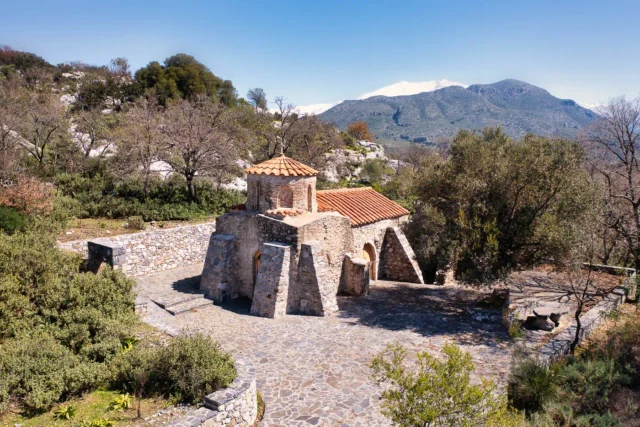
Monastery of the Holy Spirit
It is located east of Kissos and the date of its foundation remains unknown. According to one version, it was created at the end of the second Byzantine period (961-1204 AD) or during the early Venetian occupation of Crete. It functioned as an autonomous parish monastery from its foundation until June 15, 1821, when it was destroyed by armed Turkish Cretans, who in their attack slaughtered the monks and set fire to the building complex.
The monastery was annexed as a metochion to the then nearest and strongest monastery of Preveli and in 1836, under the guidance of Bishop Nikodemos Soumpasakis of Lamis, the “School of the Holy Spirit” was founded and operated, which is included among the most important spiritual centers of Turkish-occupied Crete in the 19th century.
In the area surrounding the Monastery there is a monument to the fallen in honor of the two hundred – mainly Mani – volunteers of the military corps of Dimitrios Petropoulakis who were killed in battle with the Turks on December 5, 1868. In recent years, after actions of the metropolis of Lampis, Syvritos and Sfakion, the monastery is operating again.
Locations and others
- “The Old Fountain”: located below the central square of the village and has decorative elements.
- The Forest in the Vatolakos: it was created in 1985 by the Rethymno Prefecture Forestry Directorate and covers an area of approximately 600 acres, while its flora includes pines, cypresses, acacias, olive trees, herbs, etc.
- Agia Paraskevi location: in this area where the chapel of the same name is located there is a spring, while the area is covered with trees such as plane trees and junipers, fruit trees and green bushes. North of the forest is the Kissano gorge with the Kokkinos Detis where birds of prey (vultures, hawks, etc.) nest.
- “The Sign”: the natural clock of the locals.
- The Yous Campos plateau.
Caves
- Agrimokephali: located on the hill of the same name, at an altitude of 1200 meters, north of the village and has dimensions of 6 m x 3.5 m x 2 m.
- Gero Spilio: northwest of the village. The cave has now disappeared due to a landslide.
- “Stsi Kantinosppilius”: small caves that owe their name to the butterflies (kantinele in the local dialect) that they host. They are located north of the hill Koupos, at an altitude of 1300 meters.
- Kokkinos Detis: with dimensions of 2.5 m x 6 m x 1.6 m, it is located at the location of Faraggi, at an altitude of 900 meters northeast of Kissos. Its name is due to the color of the cliff (deti) on which it is located.
- Trochalodema: it has dimensions of 4 m x 1.6 m x 4 m and is located in the homonymous location, in the wider area of Kampos.
- Ta Spiliaria: located southeast of Kissos.
Settlement: Key Points
- Historical references: Kissos is recorded in 1577 in the catalog “Descrizione dell’ Isola di Creta” by Francesco Barozzi as Chisso.
- Location: Kissos is built on the southwestern foothills of Mount Kedros at an altitude of 630 meters.
- Historical significance: During the Occupation, the local population actively participated in the National Resistance.
- Population data:
YearPopulationNotes1583222188120819002131928247194025419512051961204197117719811341991126200199201148202160- Current status: Inhabited, with a population of 60 as of 2021.
References
Access
Kissos is 21.5 kilometers away from the Rethymno and 4.1 kilometers away from Spili






There are no comments yet.